
Property Owner
Land Surveying
Sussex Surveyors LLP work closely with Foresite Geomatics Ltd, who use the latest technology and survey techniques to provide their clients with a full range of high-quality and cost-effective services. They have experience of working on projects of all sizes, building lasting, trusting relationships with their clients.
Their wealth of knowledge ensures they promptly deliver accurate data, which allows clients to plan, design and construct while reducing the likelihood of unforeseen costs and delays, ensuring more efficient and successful projects.
Services:
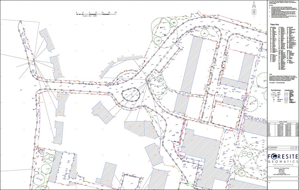
Topographical Surveys
A topographical survey provides a detailed and accurate representation of the natural and man-made features of a piece of land. It serves as a fundamental tool for informed decision-making, efficient design, and successful execution of construction or development projects while minimising risks and maximising cost-effectiveness.
Boundary Surveys
Boundary surveys and land registry play crucial roles in defining and safeguarding property rights and boundaries. A boundary survey is a detailed examination and mapping of a property’s physical boundaries. It involves measuring the land, identifying existing markers or monuments, and recording precise details about property lines, corners, and any encroachments or discrepancies.
This survey is instrumental in preventing disputes between neighbouring property owners and ensuring that landowners have a clear understanding of their property’s limits.
Measured Building Surveys
Measured building surveys involve comprehensive assessments and documentation of a structure’s dimensions, layout, and features. These surveys employ a range of cutting-edge technologies, such as laser scanning, 3D modelling, and precise measurement tools, to create accurate representations of buildings. They provide architects, engineers, and construction professionals with crucial data for renovation, refurbishment, or new construction projects. The surveys capture intricate details like floor plans, elevations, and sections, ensuring an exhaustive understanding of the building’s existing conditions. From heritage sites to modern structures, these surveys are instrumental in maintaining historical integrity, enhancing designs, and facilitating seamless construction processes. They serve as the cornerstone for informed decision-making, enabling stakeholders to optimise space, improve efficiency, and achieve architectural excellence.
Volumetric Surveys
Volumetric surveys are crucial in various industries, especially in construction, mining, and land development, as they provide precise measurements of three-dimensional spaces. These surveys involve the calculation of volumes for a specific area, whether it’s determining the quantity of material to be excavated for construction or assessing the stockpile inventory in mining operations. By utilizing advanced surveying techniques and technology like drones, LiDAR (Light Detection and Ranging), or GPS, these surveys offer accurate and detailed information about the terrain or structure being analysed.
Deformation Monitoring
Deformation or monitoring surveys are conducted to measure and analyse changes in the shape or position of structures, terrain, or objects over time. The primary goal of deformation surveys is to detect and quantify movements, subsidence, or shifts in the monitored area, allowing for proactive measures to address potential risks or structural issues.
Using our advanced surveying instruments like total stations, GPS, and inclinometers, they measure changes in elevation, angles, and distances with high precision. Continuous monitoring of key control points helps us to identify any deviations from the expected positions, allowing for prompt intervention in case of structural movement or settlement.
Utility Surveys
Underground utility surveys are carried out using a combination of Electromagnetic Location (EML) and Ground Penetrating Radar (GPR) methods. All utilities are physically marked/sprayed on the ground, the information is transferred onto a Topographical / Land Survey and delivered as a final drawing in AutoCAD format.
Underground utility surveys would be related to the Ordnance Survey National Grid Reference System (OSGB36) and Ordnance Datum (AOD).
Survey data is post-processed in-house through the use of dedicated survey mapping software and rigorous QA / QC procedures to ensure they deliver consistent and reliable results, delivered in a variety of industry-standard 2D and 3D formats.
Engineering Services
Foresite Geomatics team of experienced geospatial engineering surveyors, integrated with the latest high-precision total stations and proven processes, allows them to deliver an efficient and cost-effective solution to your site control and setting-out requirements.
Their engineering services include:
- Site Setout – using high-accuracy total stations, they can transfer your CAD designs to the real world using established workflows, along with stringent checking procedures and QA.
- Site Control – Foresite Geomatics have many years of experience establishing and transferring accurate site control on a wide range of construction sites and buildings.
- As-built Surveys – can be produced for project records as the project advances.
Volume Surveys – when required, they can produce stockpile volumes to assist with extraction quantities and earthworks. - Deformation Monitoring – they can provide movement and crack monitoring for buildings or structures. They monitor for any movement while construction progresses and produce detailed easy-to-read reports on the findings.
The button above allows you to submit your quotation request online and we will email you your quote. You will be able to accept and proceed with the quote simply by following links in the email you receive. At all times, the team are available if you would prefer to speak to someone, by phone or email for any other enquiries
PLEASE GET IN
TOUCH FOR more
information